Tuesday, August 15, 2023

Relationships with rivers, like those with people.


I’m often asked how many times I’ve paddled this river or that one. But unfortunately, after 26 years leading these tours, I’ve lost track. One day I might pull out my old records and count, but for now, I’m less focused on the number of times I’ve paddled the 70+ waterways on my tour list than on the relationships I’ve established with them.

Relationships with rivers are like those with people. Some are born of simple geography, like the next-door neighbor who, through nothing more than occasional chats over the fence, becomes as familiar as family. Others are the stuff of chemistry, sparked to life by something as simple as a glance, at the driver in the car next to us at a stop light; at a person studying at the next table in the library; at a stranger who sits next to us at a lecture…..at a glistening pool of blue water that we stumble upon, deep in a Florida forest. We turn our head, we look up from our book, we round the bend in a forest trail, and our eyes are met by a beauty unlike any we have seen before. We are consumed by a wild, breathless attraction.

There’s magic in those first moments of breathless attraction to a person or place. But, it’s not until we come to know them deeply—their flaws, their blemishes, their troubled past and underlying illnesses—that we develop the kind of true, deep connection that moves us to do anything to protect them.

As I sit here compiling my schedule for the coming weeks, I don’t see waterways for which I’m still in early throes of breathless attraction. Instead, I see places as familiar and dear to me as old friends and family members. I see grizzled old-timers, slow but deliberate in their movements, alongside glistening sprites, who spend their days singing and dancing and playing with every boulder and snag they encounter; I see sages, whose rock-bone faces are scrawled with lessons of the ages, next to geologic youngsters. Some on this list are ephemeral. Their existence is intimately tuned to the pulses of life, borning and dying to the rhythms of seasons and rain cycles. Like the species that depend on them, these waterways live by the credo, “live fast and die young…….and wait for the next big rain!”

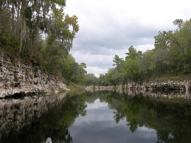
Suwannee (Monday 8/07 & Thursday 8/24) is my famous friend. You’d never know it to meet her.  Every warm summer day, people flock to her banks and refresh in her cool waters. Paddlers skim her dark surface year-round. Her human suitors have even written songs about her (which I hear all-too-often ;o). But she remains humble. Aside from the occasional splash of a leaping sturgeon and the gentle percussion she plays against the rocks of the middle river---"popping,” “blipping,” “glugging” and “tinkling” are words I’ve used when trying to describe the beautiful music she plays in the small pockets and chambers at the water’s edge---the Suwannee carries herself with a quiet, unassuming elegance.

Cedar Keys (Friday 8/11 & Tuesday 8/29) are the elders I don’t see often enough, the ones from whom I always walk away feeling rejuvenated, reconnected and vowing to visit more often. In other cultures, they would be revered as tribal shamans, keepers of ancient knowledge of our lands and waters, passed to them by ancestors of a hundred generations. They remind us, in the quiet way of all great teachers, that all nature is sacred; that we should listen.

Those who spend time with these island elders--Atsena Otie, Hog, Deer, McClamory, Snake, Seahorse, too many to name—and listen with their heart, hear stories ancient as the sand and the tides, whispered on sea-breezes and scratched into rustling parchments of palm fronds. Woven through these stories and connecting them by an unbroken thread back to the first Floridians, is a single, powerful theme: this land has stood for millennia and could stand millennia more, if we learn the lessons of our predecessors and let them guide us forward.

Prairie Creek (Monday, August 14) is one of my more reclusive friends. She’s the neighbor everyone loves, but who only receives guests when the mood (and in her case, water levels) so move her. When allowed to enter, visitors to Prairie Creek’s inner sanctum find themselves immersed in that special kind of wonderland found only on narrow creeks that wind through towering swamp forests of bald cypress, ash, tupelo and red maples. Birders are treated to a nice mix of waders, water birds and species more associated with the forest in the creek’s upper end, near Newnans Lake. Many species of wood peckers, warblers (including prothonotaries and parulas, in summer), and all manner of perching birds love it here. Owls—especially barred owls—are frequently seen. For years, we were welcomed on every paddle, to a certain section of the forest by a beloved barred owl who became something of a mascot. Limpkins are surprisingly common in the occasional sunny spots. Deer and wild hogs are common too. Quiet paddlers might spot a hog enjoying the clay-lined “wallow” we pass on a high spot near the creek’s edge. Best of all, this natural wonderland is practically in Gainesville’s back yard.

Steinhatchee River (Thursday, 9/15) is as moody as one would expect from a recluse who lives quietly in a remote corner of the Big Bend region of the Gulf Coast. As with all recluses, you never know what you’re going to get when you visit her. On cool winter days, when the east winds blow the coastal waters seaward, she might surprise you with waters so low you’re forced to portage a 100-foot expanse of beautifully-sculpted limestone. Other days, she’ll be surging with flood waters delivered from her birth mother, Mallory Swamp. On those days (the vast majority) when water levels are ideal, she’ll welcome you with an enticing spread of habitats, ranging from a narrow stream with high banks crowded with upland shrubs and trees to an open, sunny section lined with coastal forests and salt marshes. In certain seasons, this stretch offers slow, mindful paddlers an incredible floral display.

Ocklawaha (Monday, 8/21 & Friday, 9/22) and I are the kind of friends who often finish each other’s sentences. When a customer asks what wildlife we might see and I begin to rattle off names, she interjects a chorus of birdsong, chirps, fizzing insects and the occasional grunt of a pig frog for good measure. Likewise, when she wails through the trap doors of Kirkpatrick Dam, I feel compelled to explain to my companions that the lament they’re hearing is that of a river held captive since the 1960’s, when the State of Florida attempted to gouge a canal across Central Florida from the St Johns River to the Gulf of Mexico. Fortunately, that assault was stopped after a couple of years, but not before this dam was completed, blocking the natural flow and impounding 16 miles of the river in a huge pool called Rodman Reservoir. Efforts to drain this reservoir and restore the river’s life-giving flow are ongoing, led by groups like Florida Defenders of the Environment. One day, hopefully soon, the growing chorus of sympathetic voices will end the dam and allow the Ocklawaha to resume her ancient song, unfettered.

Waccasassa and Wekiva Rivers (Wednesday 9/06) are the beautiful sisters who live beyond the outskirts of town. Few people know them, or try. Those who do and who follow them along their spring-water trails into the forests and listen closely to their whispered stories, are often mesmerized. On our excursions into this realm, I often hear nothing but the dip and swish of paddles, as our kayaks glide through a series of habitats that transition from sun-washed, coastal mixed-hardwoods into a shaded hydric hammock where swamp dogwoods, buttonbush, yaupon holly, hawthorns and red buckeye form an intimate understory overtopped by a closed canopy of tall oaks, green ash, pignut hickories and river elms. Birders smile as their binoculars find kites (swallow-tailed and Mississippi), ospreys, kingbirds, herons and egrets of all the common clans, belted kingfishers, warblers and perchers. As everywhere in North Florida, the once-elusive limpkins have become relatively common. Sharing in the bounty of mollusks and crustaceans are yellow-crowned and black-crowned night herons.

Friday, August 4, 2023

Cedar Keys paddle Tour - Friday, Aug. 11


Time:  10:00 a.m.. 

Cost: $45 for "wanna go" members ($60 for non-members). With your own boat it's $35 for members and $45 for non-members.

Location: About 1 hr. drive west of Gainesville. 

Tour length: 3.5 - 4 hrs.  

Difficulty: Moderate. Can be more of a workout if breezy. If too windy, we don't go out.


Description


This is a 3.5 - 4-hour paddle, which includes a half hour stop on a beautiful island beach for lunch and a bit of beach combing.

Unlike other coastal regions, where civilization crowds the shore, like lemmings amassed for their mythical plunge into the sea, nature still rules Florida's Big Bend area (a.k.a. the central Gulf coast). It’s a low, wet country where the vaguely defined "shoreline" shrinks and expands with the ebb and flow of tides.

Driving west toward Cedar Key, one hardly notices the slow drop in elevation--only about a foot per mile as you approach the coast. Leaving the pine flat-woods and sandy, scrub ridges, you notice the roadside ditches becoming wetter and filled with a beautiful assortment of wetland plants. Pine forests give way to hardwood swamps, crowded with bays, hollies, and red maples.


Nearing the Gulf, a gust of warm air, tinged with sea-salt, tells you you're getting close. Another bend in the road and you're treated to one of the rarest of Florida offerings, a wide-open vista. The forest ends unnoticed as your gaze is drawn to a vast expanse of salt marshes, scattered islands and open water stretching to the horizon. 


The hundreds of little islands that line this watery coast, range in size from barren, half acre sand-spits to mile-wide islands with full forest of palms, oaks and other species of the coastal hardwoods. For the mindful paddler who takes the time to truly explore, the species-rich communities that crowd these islands never get boring. And, if you lose track of time and suddenly find that you've run out of daylight (I'm speaking from experience here), that's not so bad either. As dusk settles and all you can hear are the breezes, you'll be treated to a famous Gulf Coast sunset, where the silhouettes of palms, wind-gnarled oaks, pines and mangroves are cast against a smoldering sun. It's the stuff of dreams; a place where all the world is right.


In 1867, naturalist John Muir described Cedar Key as being "surrounded by scores of other keys, many of them looking like a clump of palms, arranged like a tasteful bouquet, and placed in the sea to be kept fresh. Others have quite a sprinkling of oaks and junipers, beautifully united with vines. Still others consist of shells, with a few grasses and mangroves circled with a rim of rushes." 


Wildlife

Wildlife watching is great in this area, especially for birders. Pelicans (brown year-round and white in summer months), osprey, cormorants, gulls, oystercatchers, skimmers and a dizzying menagerie of plovers and waders will keep your binoculars hoisted. In warm months (and sometimes in winter) we see magnificent frigate birds soaring on elegant, long wings (the largest wing-to-body size ratio of any birds). We often see bottle-nosed dolphins on this trip, as well as rays and other fish. In summer months, manatees sometimes pop their head up for a peek at who's paddling past.


History


In addition to its richness of wildlife, the Cedar Key area has many archaeological sites. When the earliest Floridians arrived over 15,000 years ago, their lives revolved around following the roaming herds of huge Ice Age mammals, Mammoths, mastodons, giant camels and Galapagos style tortoises were on the menu. Later--thousands of years later--warming temperatures ended the Ice Age and the "mega fauna" adapted to it. For the native people, these changes meant adapt their diet and lifeways or perish. They adapted, beautifully.


By 2,000 - 3,000 B.C., the coastal people were living in permanent villages on higher ground. Seafood dominated their diet, especially shellfish, as revealed by the area's many large shell middens, or mounds. where generations of villagers tossed their table scraps. Oyster, conch and whelk shells dominate these heaps. However, their diet was more diverse than appearances suggest. Researchers have identified remains of many other species--both land and sea animals--as well as plant remains among the smaller bits between the shells. These middens are found on the nearby mainland and on many of these islands, including some which we will explore on this trip.


During the Second Seminole War (1835 - '42) Seahorse Key, near Cedar Key, was the location of a military hospital and a detention center where Indians were kept before being shipped west to the Indian Territories. On nearby Atsena Otie island, the army built a supply depot. 


After Florida became a State, the U.S government built a lighthouse on Seahorse Key. Later, during the Civil War, it was used by the Union Army as a military prison. 


In the final decades of the 19th century, three large pencil-manufacturing mills were operating on the island. Between them, they buzzed nearly 100,000 cedar trees per year into pencils which were shipped to distant ports. The town's population grew to nearly 300 before the region's cedar trees were virtually wiped out and the mills were forced to close. The area took a second hit when, about that same time, a hurricane destroyed most of the homes. 


Paddlers who visit this small island, can enjoy a short hike to the old graveyard where they can find the graves of some notable characters in Cedar Keys earlier days. Pirates, pioneer families, politicians and mill workers are among the silent residents of this island.  


Highlights


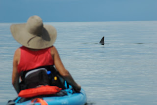
In addition to being a haven for an amazing assortment of water birds and interesting sea life, this trip's open waters and the chance to do a bit of beach combing are a nice change of pace from our inland excursions. Dolphins and, less frequently, manatees sometimes swim past. And no, those small fins circling your boat are probably not sharks! They're far more likely to be the tips of ray "wings" or the fins of "tailing" redfish.  


Difficulty


This is a moderately strenuous (depending on the strength of breezes) paddle on open water. We sometimes encounter small chop and wave action as we cross deeper channels between some of the barrier islands. If it's uncomfortably breezy or the water is choppy, we won't go out.


Bar-Hopping the Suwannee River (sand bars, that is ;o) -- this Monday, Aug 7


This paddle usually has us on the water for about 3.5 - 4 hours, including a lunch stop. 

Time: 9:00 AM. at the Suwannee (about 1.5 hours NW of Gainesville)

Cost is $50 for "wanna go" members ($65 for non-members). With your own boat it's $40 for members ($50 for non-members). * NOTE - There is also an additional $5 park entry fee to Suwannee River State Park.  
 
Upper Suwannee offers vistas unlike any other river in North Florida

Description

The sand bars that line much of this stretch are not only attractive; they make excellent pit-stops for a quick jump in the river and for our lunch break. The biggest are "point bars," formed on sharp bends in the river where sand is deposited by the water as it slows going around the inside of the bend. Growing conditions for plants are harsh on point bars. When plants do take hold, a predictable succession forms, starting with tough, low herbs and grasses, followed by shrubs and finally trees. Black willows commonly top the bar.


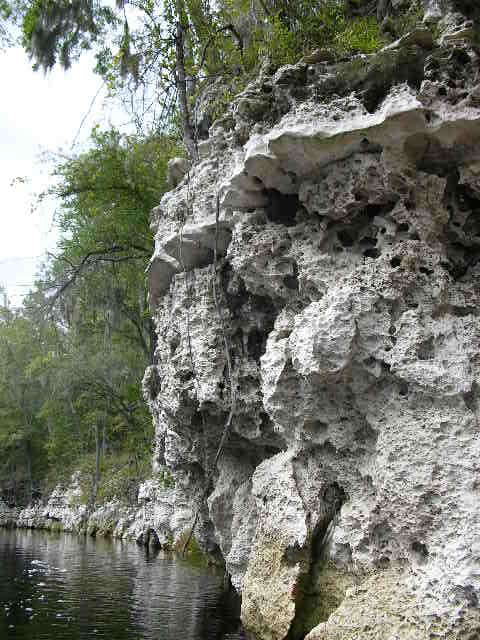
Behind the sand bars, there’s limestone. Few places in North Florida showcase limestone more beautifully than the section we’ll paddle on this trip. Whether it’s individual stone outcroppings along the lower river, or massive, 40-foot stone walls, there are few places along this stretch without limestone.


Bluffs of 40 million yr old limestone flank the river

This cream to grey colored sedimentary rock was formed during times when the world’s water levels were much higher than today and Florida lay at the bottom of a shallow sea.

Shells and cartilage of sea creatures settled on the sea floor and accumulated in layers ranging from several feet to nearly half a mile thick. Most of what we’ll see on this trip is Suwannee limestone, formed on the floor of a sea that stood here nearly 35 million years ago.


Among the more interesting fossils found here are those of ancient dugongs, ancestors of today’s manatees. In 1982, college students from UF found the skull and partial skeleton of an extinct manatee on the riverbank near White Springs. These creatures lived in the shallow sea that covered this area 20 million years ago, during the Miocene era. Paleontologists soon uncovered three more specimens. Of the four, one belonged to a previously unknown genus, one was the first skull of its genus, and one was the best-preserved specimen of its species ever found. Two of the animals were from a subfamily of sea cows previously unknown in the New World. Interestingly, all appear to have co-existed. Imagine the manatee tours!


Wildlife


The plant communities we pass on this tour reflect the higher, drier terrain flanking this section of the Suwannee. The combination of high, sandy banks and dark, tannin-stained water, makes aquatic vegetation relatively scarce. This, in turn, means fewer fish species and a less complex web of life than we see along spring runs, for instance.


On shore, there's no shortage of greenery. Lanky, coastal plain willows, river birch, and Ogechee tupelos along with a number of sedge and grass species cling to the higher, firmer sand banks. Atop the bluffs, an unbroken forest of oaks and pines rule. Away from the river, the local terrain is relatively dry, so animals such as deer, bobcats, hogs, turkey and an occasional bear come to the water’s edge for a drink, though sightings are relatively scarce. Also residing in this stretch of the river is a fair number of beavers. You don't have to look hard to see their sign, including long slides which they use to skid limbs, branches and other woody snacks down to the river. Keep an eye out for otters, as well.


Birds are scarcer here than other sections. But we do see above-average numbers of Mississippi and swallow-tailed kites in the spring and summer months. Eagles, osprey and vultures are commonly seen soaring.


History


Local lore long held that the name, "Suwannee" came from the Creek Indian word "Suwani," meaning echo. When I first learned this, I was still a young wanderling who had not yet seen the echoic canyons of the upper Suwannee, so didn't buy the story. Today, being more familiar with this river, I have to admit that any homesick Alpen-folk who want to yodel, will find the acoustics of some of Suwannee's deeper gorges (not seen on this trip) well-suited to their art. But, I'm still not convinced that this is the names origin. . . . origin. . . origin . . .


A more likely source of the name was the Spanish mission, San Juan de Guacara, which was located alongside the Suwannee, west of today's Live Oak. For most of the 1600's, a network of Christian missions dominated life in north Florida. Today', many north Florida place-names trace their roots to that important era. San Felasco Hammock (from Mission San Francisco), San Pedro Bay and a number of rivers--St. Johns, Santa Fe and St Mary's, to name a few--preserve the names of Spanish missions that sat along their banks. San Juan de Guacara was located near Charles Spring, where it served as a rest stop and ferry landing for the travelers on the Mission Trail, the main artery of transportation across North Florida at the time, which crossed the Suwannee here.


 Following the demise of the mission system in the early 1700's, the river was called San Juanee, or "little San Juan" to distinguish it from the other, larger San Juan River to the east, today's St. Johns River. From there, it's not hard to imagine the name slowly evolving to 'Suwannee.'

The confluence of the Withlacoochee River and the Suwannee, a beautiful area now protected by Suwannee River S.P., (and the place where our trip will end) was once the site of the thriving, 19th century riverboat community of Columbus. At normal water levels, this confluence was considered the head of navigation for the river's steamboats. Today, all that remains of the town is its cemetery, which you can visit along one of Suwannee River S.P.'s. excellent hiking trails (some of my favorite trails in the State). Earthworks built by confederate soldiers to protect the bridge across the river during the Civil War can also be seen. We'll take a short stroll to look at these remains before our paddle.


swallow-tailed kites are common in summer

Difficulty


This is an easy paddle, going downstream all the way. But even though we go with the current, it's fairly slow, so you'll have to paddle a bit. Those who've paddled with me before, know I prefer moving slowly and taking in the sights and sounds. You're welcome to go at your own pace - speed's not an issue.